
 On The Road
by: Bill Oetinger 10/1/2006
Southern Oregon Tour
In 1995, the Santa Rosa Cycling Club staged its first ever week-long cycle-tour, using a packet of routes borrowed from the Sacramento Wheelmen. In 1996, we laid out the first tour on our own: The Crater-to-Coast Tour in Southern Oregon. In six stages, it went from the hills above Ashland up to Crater Lake, then across valleys and hills to the coast, and finally down the coast to a finish near Crescent City, California.
Ten years later--in the summer of 2005--we revisited that Oregon tour, but we revised the route to turn it into a loop that began and ended in Ashland. Ten years ago we had the services of a chartered bus that allowed us to end the tour far from where we started it. We did not have that option the second time around, so we needed to come back at the finish to where we had stashed our car pool fleet for the week. This logistical challenge turned out to be a blessing in disguise, as it opened up some wonderful new country for us on our way back over the mountains from the coast to Ashland.
This is a thumbnail sketch of that tour, offered for your consideration here as something you might want to take on yourself. The fact that it’s a loop makes it accessible to just about any cyclist. You don’t need to mount a complex production with a shuttle bus to make it happen. You could do it as we did it, with a truck hauling the luggage, or you could do it on your own, schlepping your own gear. It’s set up as a campground-based tour, but it might just be possible to do it cycling on your plastic and staying at inns along the way.
It’s a long tour for one week. We cycled for nine days straight, which is all the days you can wring out of two weekends and five weekdays. But as I will note later, it could be done in eight days. It’s long on miles too. With a few scenic diversions thrown in, I logged almost 590 miles over the nine days. In spite of all those miles, it wasn’t a difficult tour, overall. We accumulated 41,000’ of elevation gain, but it was never brutal climbing, and I don’t recall feeling trashed at the end of any stage. We typically had loads of daylight left after we got off the bikes...time for washing up, eating, relaxing, or even whizzing a frisbee around camp.
Stage 1: Ashland to Howard Prairie Lake • 22 miles, 3500’
Obviously, 22 miles is not going to add up to much of a stage (although note the elevation gain: much of it is uphill). We thought of this as our tour prologue; something to do on our travel day. Coming from California, we chose to begin our tour at the most accessible, most southerly point on the loop, where it interesects Interstate-5 at Ashland. It took us about six hours to drive to Ashland, and that left us a little sliver of afternoon in which to grind up the big climb on Dead Indian Highway and down the other side of the ridge to camp. That put us right where we needed to be start our first full stage in the morning. We made arrangements to stash our car pool fleet at the Ashland YMCA, which is just up the off-ramp from I-5 and right on the route to camp. It has the added bonus of offering us showers at the end of our final stage.If you look at the miles for that final stage--37--you can quite easily figure out that combining that stage and Stage 1 would make one stage of just under 60 miles. It worked for us to break those miles up into two smaller sections to be done on our travel days, but it certainly could be done as one stage, and once you do that, you are free to begin and end the tour at any point on the loop that works for your own travel plans. There is nothing carved in stone that says you must start in Ashland.
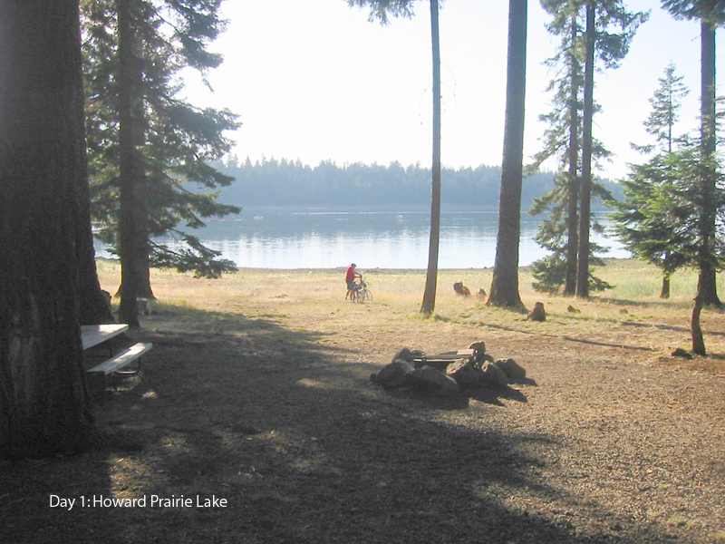 The bulk of that first, prologue stage is taken up with Dead Indian Memorial Highway. You pick it up right out of Ashland and stick with it for over 16 miles, the first 12 of which are steadily uphill. The climbing is never painful, but it does go on for what seems like a long time, especially if it’s a hot afternoon, which is very likely. Over the top, there’s a descent of a few miles and then a rolling run south along the lake to camp (left). The camp is a decent facility with plenty of room for tenters. This is one of the stages that doesn’t have an obvious option for indoor lodgings nearby. It’s possible some B&B exists up in those woods somewhere, but I’ve never tried to find one, so can’t say for sure.
 Stage 2: Howard Prairie Lake to Mazama Village • 70 miles, 4400’
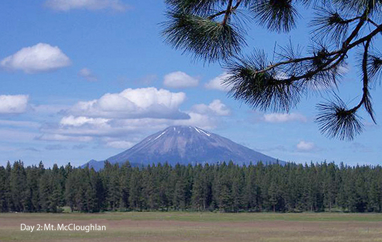
Given just a brief look at a map, it would be easy to write this stage off as being all about its destination: Crater Lake National Park. But that would be both inaccurate and a slight to the very real charms of what lies between the start and the destination.For one thing, although the stage does end up in the national park, it stops short of the lake. That particular gratification will have to be deferred until tomorrow. The stage ends in Mazama Village, the park headquarters, which is well below the rim of the ancient caldera of Mount Mazama. (Mazama was the highest of all the Cascade peaks, all of which are volcanic in origin. It blew its top off, a la Mt. St. Helens, leaving the big hole in the middle, which has been filled in by Crater Lake.)
 But I’m getting ahead of myself, talking about the famous lake when we’re not there yet. Instead, let’s go back to Howard Prairie Lake--a much more modest puddle--and begin there. The first 25 miles of the stage roll up and down through fir forest typical of the Cascades, with the occasional open meadow (left) or small lake to break up the passing colonnade of tree trunks. After a fast descent of a couple of miles around mile 25, things change a bit.
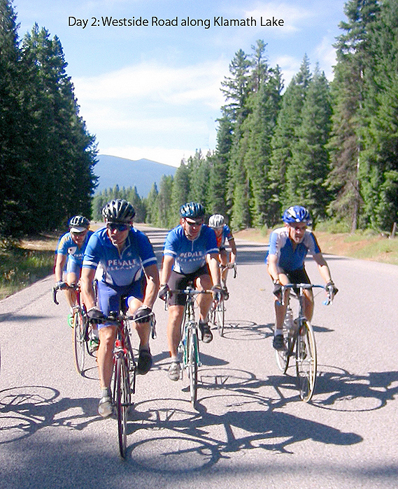 You have arrived at the shore of Upper Klamath Lake, or more precisely, at the sprawling wetlands that surround the big lake and constitute the Upper Klamath National Wildlife Refuge. Westside Road (left) and the little roads that follow spend the next 35 miles bumping along the fringe of these wetlands and meadows. Now the open spaces dominate--meadows, marshes, and lake--and the walls of trees become the exception rather than the rule. It’s all very pleasant and pretty and about as easy as bike riding can be. And it’s nearly car-free. Not much out there at all.
After passing through the tiny town of Fort Klamath at mile 53, the land begins to tilt uphill again in a dedicated sort of way. No more rollers. This is a long grind, all the way to camp. The final ten miles of the stage gain 1600’, which works out to an average grade of about 3%. And for once, that’s an accurate indicator of what you’ll find on the road...just a long, easy pull up the side of the old volcanic cone. Here and there along the way you can catch some lovely vistas from near the road down into the canyon of Annie Creek. Stopping to admire these views provides a good excuse for putting a foot down and breaking the climb up into bite-sized chunks.
Mazama Village is a large campground hidden away amidst the forest trees. It’s a pleasant enough camp, but has no special claim to fame except for being where we want it to be and having showers. Were you attempting this as a lodgings-based tour, the obvious, affordable choice here would be the Mazama Village Motor Inn, adjacent to the camp. But the more interesting option would be the grand old Crater Lake Lodge, up on the rim. More about that later.
Stage 3: Mazama Village to Horseshoe Bend • 64 miles, 2500’ or 79miles, 4000’
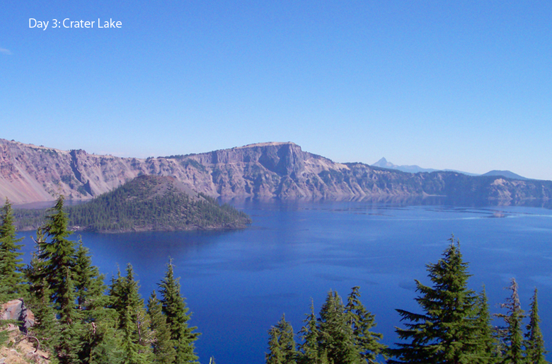 The marquee attraction on this day is certainly Crater Lake (left). It’s probably one of the star attractions of the whole tour. But the stage is more than just one lake, no matter how special it is. There is good stuff around almost every bend, all day long.
 The longer-shorter route options boil down to this: do you want to go around the west rim of the lake (shorter) or the east rim (longer and hillier)? Having done the longer east rim on my first tour here, it was easy for me to choose the shorter, less ambitious west rim this time. All in all, the only reason I can think of for doing the longer east rim is simply to pound the extra miles. It’s considerably harder (as in hillier) and for all that effort, you don’t really see all that much more of the lake, as the road on that side of the lake drops off the rim and the lake is out of sight for long stretches, whereas on the west rim, you are almost always right up on the rim, with the lake in sight.
What’s more, if you do the east rim, you miss one of the very best attractions on the west rim: Crater Lake Lodge. This is a classic National Park-style lodge built 90 years ago. It has undergone a restoration in recent years and now looks wonderful. And talk about location: it’s right on the rim, with superb views over the lake. I’m a sucker for grand old park lodges, but even if you don’t care about that, the view alone is reason enough to come here.
I’m not going to spool out the entire Crater Lake story here. You probably learned it in school or have been there or have seen it on some nature show, or at least have seen the lake in a million photographs on everything from jigsaw puzzles to nature calendars. It is an icon. For now, just the basics: as noted earlier, Mount Mazama was a big, volcanic cone, like Hood and Shasta and Rainer. And like St. Helens and Lassen, it blew up, quite recently, in geologic terms: just 7700 years ago. The top of the mountain blew off very cleanly, leaving the teacup-shaped caldera. Filled by snowmelt and nothing else, the lake has remained incredibly clean and pure, and as it’s the deepest lake in North America, the resulting waters show an almost unreal deep blue color which can’t quite be captured in photographs. You have to see it in person on a sunny day to appreciate the intensity of the color.
For such a little lake, it packs quite a wallop as a roadside attraction, and riding around the rim--on either side--is a great adventure. First though, you have to climb up to the rim, and that’s an almost 8-mile climb from Mazama Village...never brutally steep, but substantial work. After soaking up all the scenery you can stand along the rim, you get back that 8-mile climb and then some over the balance of the stage. There is some up and down as you work your way along the rim, but eventually, you drop off the edge and keep dropping, nearly constantly, for the next 40+ miles. Okay, there is one 2-mile climb in there, and a lot of the descent is so gradual you’ll be pedaling. But overall, it’s down, down, down, and some of it is seriously fast and fun. Total elevation loss will be somewhere between 7500’ and 9000’.
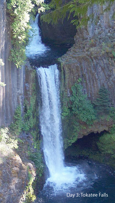 First stop on the descent is Diamond Lake, a more generic but nevertheless very pretty lake. There is a flat-to-rolling paved bike trail along the lake and then the 2-mile climb up from the lake. From then on, you descend for the rest of the stage, following the canyon of the Umpqua River. Along the way, there are three waterfalls that are worth side trips. Clearwater Falls is small but very pretty, and is easily accessible in bike shoes. Watson Falls is the second highest waterfall in Oregon (after Multnomah Falls) and is quite impressive. But it’s more of a walk--a half mile--than you can do in most cleated shoes. We put a sag here with a box of street shoes and swapped out our footgear. Tokatee Falls is the prettiest (left) and is just a short ride off on a side road.
 Horseshoe Bend is a USFS camp on the Umpqua. A nice camp, but with no showers. It offers a good group site, set off on its own. You can rinse off the salt in the river, but it’s cold! For more refined accommodations, consider the Steamboat Inn, just a few miles further downstream. It’s a very nice resort. Pricey, but worth it.
Stage 4: Horseshoe Bend to Camas Valley • 79 miles, 4000’
This is one of the harder stages on the tour. It’s long, it can be hot, and it contains some challenging climbs late in the day. It starts out easy enough, with over 30 miles of gentle downhill, rolling along in the bottom of the green and shady Umpqua River canyon. My only photo for this stage shows our gnomic mascot Honir at Colliding Rivers (left), a scenic wayside at mile 30 where the Umpqua River and the Little River ram into each other almost head-on, which they say makes quite a show at high water. (We’re always here in the summer when the waters are very quiet, but it still makes a good spot for a break.) As you near the end of those miles, the valley floor flattens out and the main road--Hwy 138--becomes too busy for bikes, so we seek out side roads that are tranquil but hilly.
 Mid-stage--from mile 47 to mile 51--you have to work your way through the small city of Roseburg. Fortunately, a fairly attractive and uncluttered way exists for doing this, and the urban transit is about as painless as it can be. Once out the other side of town though, “painless” might not be the word that comes to your mind to describe the roads. There are two climbs, on Coos Bay Wagon Road and Hwy 42, that will make most riders work, if not suffer. The first is shorter but steeper; the latter is longer--about eight miles--but less steep.
On both our Oregon trips, we have stayed on the campus of Camas Valley High School. Camas Valley is a little town 35 miles west of Roseburg. There are no campgrounds in any convenient spots out there, at least none sporting showers and being on paved roads. So the high school it is. Those in charge have always been most helpful and hospitable. I have no idea how they would respond to a request from just two or three people to pitch a tent and have access to the showers, but for a group of a couple of dozen, they didn’t bat an eye.
I feel certain there must be a few B&B’s salted away in these coastal hills. It’s a moderately trendy area, with a growing and relatively prestigious wine industry to pull in the tourists. Failing the B&B, there are plenty of generic motels in Roseburg, although that’s not really the right place to be stopping to make these stages work.
Stage 5: Camas Valley to Sunset Bay • 68 miles, 4000’ - Optional out-&-back at the finish: add 12 miles
The basic stage today is about as easy as any 68-mile ride you’ll ever do. Adding the 12-miles from camp at the end will make it an 80-mile ride, but still a very moderate proposition, and with great rewards for the extra work. In fact, I wholeheartedly urge anyone who comes this way to do the bonus miles. To come here and not do them would be a crime. They’re the best part of the day.Almost the entire first half of the ride passes by in a pleasantly uneventful cruise downstream along the Middle Fork of the Coquille River. All mildly downhill; all mildly scenic, and all on the wide shoulder of a mid-sized highway. In the town of Myrtle Point, we lose the highway for a meandering detour along dinky farm roads in the flat, verdant valley of the river. It’s a confusing maze of lanes where a few folks got lost on our first tour through here. Second time around, we all muddled through. It’s a lovely environment for cycling: itty bitty roads wiggling along next to estuaries and rivers, backed up with dairy pastures and woods. Quiet and peaceful.
Unfortunately, we have to return to Hwy 42 for a few miles at a point where it’s starting to be a fairly busy arterial. We even ride up the shoulder of Hwy 101 for a time. But all of it is on wide shoulders and really isn’t too awful. It’s only sub-standard when compared to the nice miles that preceded it. And even this shall pass. After 12 miles of busy highways, we get to scamper off into the woods again on a hilly, backroad journey out to the beach at Sunset Bay State Park, one of the prettiest spots on the Oregon coast.
If you look at a map of this area, you can easily find the Cape Arago peninsula. A large chunk of this land mass is within the borders of three state parks, from north to south: Sunset Bay, Shore Acres, and Cape Arago. Sunset Bay has the campgrounds, including a fairly standard family-style site (with showers) and Norton Gulch, a wonderful group site, off on a little hill over the ocean, all by itself. Whatever you would have to pay and whatever lies you would have to tell about your group to reserve the group site would be worth it. It’s that special.
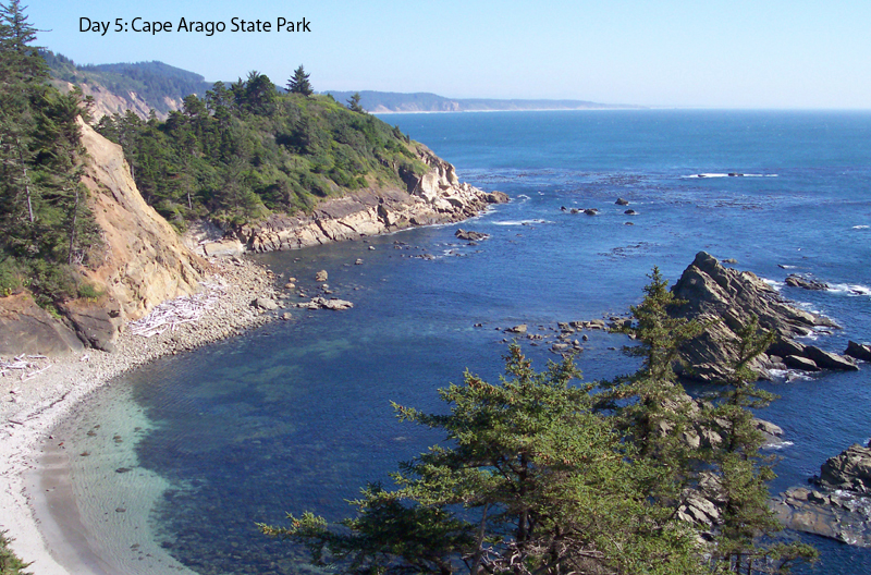 The road runs south beyond Sunset Bay to its terminus at Cape Arago, and that constitutes the out-&-back. Every inch of it is pretty,
  and the best of it is as pretty as it gets: the essential Oregon coastal experience, complete with soaring rock cliffs and standing stones, barking sea lions, pristine beach coves and unlimited ocean. That’s at the Cape (left). In between, you have Shore Acres, which is an entirely different experience. Out here on the edge of the continent, with rugged, sea-girt cliffs and wind-sculpted trees, you wouldn’t expect to find a formal garden like something from the forecourt of a French chateau. But that’s what you get (right). The wealthy Simpson family (Simpson Paper) built the estate early in the 20th century. At some point the main house burnt down, but the formal gardens remain as a state park, and they’re maintained to a high standard. It’s very much worth it to ride in to the gardens, park the bike, and wander around for an hour or two. Barefoot, if need be.
 Non-campers ought to be able to find standard lodgings in Coos Bay or Charleston (the latter is very close by) or perhaps even a B&B out on the cape, right next to the parks.
Stage 6: Sunset Bay to Powers • 68 miles, 4000’
This too is a relatively easy day. It starts with a little backtracking along the Cape Arago Highway, then turns uphill on Seven Devils Road. I love that road name, but there is nothing especially devilish about the road. It does climb quite substantially for awhile...three or four pitches that will make you work...but it’s nothing like the big passes we encounter in the mountains. And after those first few climbs, the rest of the elevation profile just about flatlines...a lazy day. Most of Seven Devils is lovely, although some of the nearby hills have been logged fairly recently, leaving things looking a little raw. The climbs on this road come bundled with descents of the same size...up the ridge from sea level and back down again.After the modest Seven Devils ups and downs, the route visits the resort lands surrounding Bandon Dunes: two or three new golf courses built in the Scottish links style that have in a very brief time risen to near the top of the chart in rankings for great American golf courses. Those who follow golf think this is a pretty cool deal here. For the cyclist, all it means is riding through an area of dunes and woods on well-paved, pretty lanes, with the occasional glimpse of fairway or trophy home back in the trees. Once through this zone of affluence, the route drops into the seaside village of Bandon. Used to be, we always went to the Bandon Creamery and got an ice cream cone at mile 25. But the bigger Tillamook Creamery--the cheese people--recently bought the Bandon outfit and closed it down. Bummer!
 So in one side of Bandon and out the other, back out into more of those winding, quiet lanes through the pretty, pastoral lands of the Coquille River basin, back through Myrtle Point and then south toward the town of Powers along the Powers Highway (left). We leave the Middle Fork of the Coquille River and now start heading upstream along the South Fork. Upstream means uphill, so the elevation profile over the final miles has a moderately upward-trending look to it. Nothing much...in fact nearly level.
 Camp in Powers means the county park just north of town, and it happens to be one of the nicer camps on the whole tour. There are decent showers and pleasant group areas, all spread out on green lawns next to a little pond. This is essentially where we departed our original tour route and struck out into new territory on our way back to Ashland. Not knowing what we might find, this very nice park came as a pleasant surprise for us and as a great relief, not least because it happens to be exactly where we need it to be to make the stages work.
Stage 7: Powers to Glendale • 74 miles, 7600’
Crater Lake notwithstanding, this just may be the most epic, most memorable day on the tour. It is something special.This is the day we climb back through the Coast Range and drop into the inland valleys that will eventually take us back to Ashland. The Coast mountains are never huge, but like their counterparts in Northern California, they are a busy, steeply folded landscape of ridges and river canyons...up and down, early and often.
Powers Highway down to the town of Powers was a nice two-lane with solid, contemporary engineering, as seen in the earlier photo from yesterday’s stage. South of Powers, it stops being a “highway” and becomes simply Powers South Road. It narrows and wiggles about more, as it becomes more intimately entangled with the South Fork of the Coquille. The river narrows too, or its gorge does. Great masses of rock fill the stream in decorative ways. Birch, alder, and aspen crowd the banks in lovely profusion. This really is one of the prettiest roads I can recall riding. It’s dang near perfect.
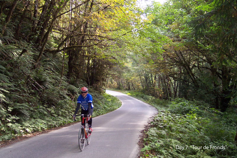 But wait...there’s more. It gets better. Turn east at mile 18 and pick up BLM Road 3348, up into the high hills (still along the Coquille, which turns east with the road). Now we’re climbing in earnest, gaining over 3000’ between mile 15 and mile 40. Some of it is seriously hard work, but most of it is easy. All of it is lovely, as the photo will attest (left). They have a local bike ride up here called the “Tour de Fronds.” Fern fronds...get it? It’s a good name. You’ve never seen such a mass of green and fuzzy ferns in one place. The little road is like a tunnel through them. I almost felt as if I were riding in the belly of some great green beast.
 Once over the highest summit at mile 40, the roads tilt downhill for most of the rest of the stage. From 40 to 47, in particular, bold descenders will be in heaven: nothing but one slinky bend after another, down and down. Good pavement. Great scenery. Everything about this stage is as nice as it would be if you drew it up as a fantasy of what a great stage could be.
The final 20 or so miles into the town of Glendale are rolling, with a few ups and a few downs. Nothing major in either department, as the pretty scenery continues along the banks of Cow Creek.
For our overnight in Glendale, we made use of another high school, and once again, the school administrators were cordial and cooperative. No problems at all. If sleeping next to the football field doesn’t appeal to you, consider the Wolf Creek Inn, just a few miles beyond Glendale on the route of Stage 8. It’s another grand old inn--a registered National Historic Landmark.
Stage 8: Glendale to Cantrall-Buckley Park • 83 miles, 5000’
This is the longest stage of the tour, but it’s doubtful many riders would name it as the hardest one. About the only thing that could make this stage brutal is heat. These interior valleys of Southern Oregon can be blisteringly hot in the summer, and if you happened to catch a scorcher on your run through here, it might turn into a rather long, tiresome day. It wasn’t that way for us though. The day was pleasantly warm. Okay, it was hot. But not killer hot.Just out of Glendale, at the start, we have to ride along the shoulder of Interstate-5 for a few miles. When local cyclists told me this was the only option, I was a little dismayed at the prospect. But in fact it turns out to be no big deal. Huge shoulders and relatively light traffic out here in the boonies. A little over two miles of easy climbing to Stage Road Pass, then over three miles of very fast, smooth descending to the Wolf Creek off-ramp and back onto back roads.
 The little town of Wolf Creek, with its grand old hotel, is the jumping off point for two really nice roads: Lower Wolf Creek Road and Lower Grave Creek Road (left). Both are quiet and mostly car-free. Both do more descending than climbing--although there is plenty of both--and all of the miles, either up or down, are perfectly scaled to bike travel...twisty and scenic and fun. It’s essentially a reprise of the wonderful mountain miles of yesterday’s epic stage.
 At mile 23, Grave Creek feeds into the Rogue River, and our route turns south--upstream--along the Rogue at one of this scenic river’s more scenic stretches. There are some quite spectacular vistas overlooking the deep canyon of the river. The road itself is less spectacular than the ones that preceded it, but is still very pleasant for cycling, which is good, because we’re on it for most of 20 miles, almost to the town of Merlin.
I always imagined Merlin, Oregon would be very quaint. How could it not be with a name like that? In fact, it sprawls in typical suburban ugliness along the road for several miles. Fortunately, we have an escape route to avoid this crud. Just before the sprawl begins, we bail onto Azalea Drive and follow a meandering route through wooded hills west of Merlin and Grants Pass. It’s mostly forest and meadow and river crossings, but with a healthy dollop of rural-residential thrown in. Not really wilderness and not really agricultural. More like big country properties for up-scale commuters.
At around mile 55, we drop out of this pleasant region of wooded hills and hit busy Hwy 199, the main connector between I-5 at Grants Pass and Hwy 101 at Crescent City. We’re only on the highway for half a mile, then return to little side roads for the duration of the stage.
When the route leaves 199 at Fish Hatchery Road, there is a very nice roadside cafe that is worth a visit. It doesn’t look like anything special from the street, but if you walk through a breezeway, you emerge in a lovely, shady garden laid out along the bank of a pretty creek. If the day is hot, this will seem like heaven, and with 28 miles to go, it’s the perfect spot to refuel for the run to camp.
The balance of the stage runs up the valley of the Applegate River. The region is know simply as The Applegate, and it has a well-deserved reputation as good cycling country. The terrain is gently rolling. Scenery is a mix of woods and pastures with the Applegate River on view now and then. This is less rural residential and more large dairy farms and horse ranches. The riding really couldn’t be much easier. From the time the route hits the Rogue at mile 23 until the finish at mile 83, the elevation rises from around 600’ to 1600’. A thousand feet in 60 miles. Not much. There are numerous extra little bumps in between that bulk up the total elevation gain--maybe ten small little-ring climbs along the way--but overall, it’s an easy cruise.
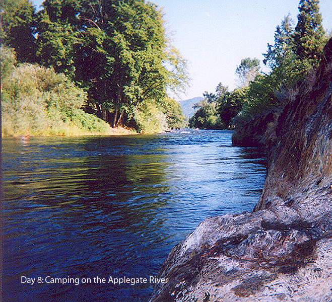 Cantrall-Buckley Park is on the bank of the river and although there are showers, most of us simply walked down to the river and fell in (left). For indoor lodgings, consider the nearby historic town of Jacksonville. It’s a wonderful old village that is designated as a historic site, and it makes the most of its lovely old pioneer architecture with loads of tourist stuff and all the quaint inns and nice restaurants you could possibly desire. If you wanted to do the tour as eight full stages (as discussed earlier), you could do a lot worse than starting from Jacksonville.
 Stage 9: Cantrall-Buckley to Ashland • 37 miles, 4000’
Note the elevation gain. More than a hundred feet per mile. If you were to couple that with the 22 miles and 3500’ of Stage 1, you’d have a day with as much climbing as any on the tour, and with the monster Dead Indian climb near the end, it just might rank as the hardest stage of all.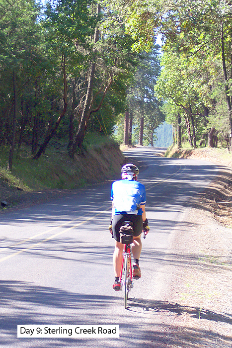 In our scheme of things, it wasn’t quite so daunting. We just needed to get back to Ashland. The big challenge on the day comes early: Sterling Creek Road (left). At mile five, it tilts up into a serious piece of work, gaining 1600’ in seven miles. For what it’s worth, it’s all pretty. Two smaller climbs and three bigger descents follow, as we work our way into the fringe of outlying residential communities surrounding Ashland.
 For a few miles the route dodges around the clutter near Hwy 99 and I-5--still nice riding...we do dodge most of the junk--and then we pick up the Bear Creek Greenway, a nice bike path/nature trail corridor that will be our home all the way into the back streets of Ashland. This is a sweet little run, not only on its own merits but also because of what it avoids: the congestion and sprawl on the main highway. The trail rolls along the pretty creek in a no-brainer sort of way, then dumps us out into a quiet, residential district, where another mile or two of side streets takes us back to the YMCA for showers.
Ashland is a major tourist destination, what with its famous Shakespeare Festival, and there are more chic and trendy restaurants here than in most cities twice its size. We piled in our cars and drove to Pasta Piatti, a nice Italian bistro with patio seating, for a wrap-up, wind-down lunch before our drive back to California. We were home before dark.
There you go...a long read but still only a brief overview of the whole package. If any of this piques your interest as something you might like to try, talk to me. I can flesh out this brief account with more precise detail.
It’s a wonderful tour. A huge variety of magnificent scenery, from the high Cascades and Crater Lake to the rocky beaches and then back over the Coast Range and along lovely river canyons. The riding is challenging but not impossibly difficult. And the logistics are simple...nothing especially complicated. It works!
Thanks to Linda Fluhrer, Tony Buffa, and Wes Hoffschildt for the use of their photos.
Bill can be reached at srccride@sonic.net