 Must Do Climbs
by: John Summerson 6/15/2010
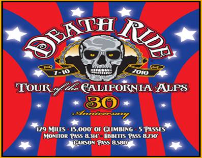
Death Riding
Besides its name what else about something called the Death Ride would tend to alarm potential riders? For one it covers almost 130 miles. For another the ride has one of the greatest elevation gain to mileage ratios of any in the nation, with approximately 15,000 feet of vertical over five climbs along its route.
The event takes place each July in the California Alps (starting point is Turtle Rock Park just north of Markleeville) and there are few areas in the state so beautiful. This is classic alpine climbing and while not among the most difficult Sierra Nevada ascents they are certainly not easy (except for the west side of Ebbetts Pass the climbs used are cat 1 or 1/2). Of course ride all in a day and your opinion of them may differ. However, wait several days for recovery and I think you will look back on the experience as time well spent.
A significant intersection in the Death Ride is the corner of Routes 4 and 89 just south of Markleeville and is one of my favorite places. I remember the first time I rode in the area many years ago, reaching that point and taking a break after going over and back on Monitor Pass. From this key spot one can head east to Monitor, south to Ebbetts or north to Carson Pass. There is a bit of peace there after the climbing battle along with a sense of isolation deep in the mountains. On that warm late spring day it was a great place to relax and dip your toes in the West Fork of the Carson River to cool off.
The Death Ride draws a huge field, filling up each year months before the event takes place. The age range of participants is wide and about 60% of those who start complete all five passes. With high season here all are open for riding so if you are not registered for the event try to get to one or more of these climbs this year. For more information on the event go to www.deathride.com.
Californians have the greatest assortment of road bike climbs to choose from in the entire country. From beyond category monsters in the Sierra Madre Mountains to more moderate climbs along the coast and the shorter but generally steeper ascents in the Bay Area there are multiple rewarding climbs for all types of riders. The following climbs, each included in the annual Death Ride, are all challenging and should be considered must do ascents for those looking to go seriously uphill on the bike. Regarding the rating listed; in major races climbs are rated numerically 1-4 dependent upon their length and grade with 4 as the least difficult classification. A hill considered more difficult than category 1 is described as hors or a beyond category climb.
Monitor Pass West
Total elevation - 2,647 ft Length - 8.2 miles
Average grade - 6.1% (9%) Rating - 1.83 (cat 1)
The west side of Monitor Pass is a solid and scenic climb within a canyon over its lower end. The beginning is very steady grade along a creek. In the middle of the route the grade flattens near a small lake giving the legs a break before the final pitch to the top. There is a small descent just before the final push up to the signed summit. The descent of this climb is fast so watch out for the cattle guards on the way down (closed in winter - Stanislaus National Forest - 209 532-3671).
Directions - From Markleeville, CA head south on Route 89 to its junction with Route 4 where the climb begins by heading east up the hill on 89.
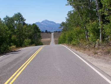
Looking down the west side of Monitor Pass
Monitor Pass East
Total elevation - 3,216 ft Length - 9.5 miles Average grade - 6.4% (10%) Rating - 2.33 (cat 1)
Monitor Pass East is a tough climb that rises out of the high desert near the Nevada border. A more difficult ascent than its western side, the grade is fairly steady and eases only over the last few miles to finish at 8,314 ft. Hot in summer as it is exposed over its entire length, the east side of Monitor is also a fun and technical descent (closed in winter - Stanislaus National Forest 209 532-3671).
Crux Stretch - The half mile that ends at the Alpine County line which is the steepest section of the climb.
Directions - From Gardnerville, NV take 395 south for approximately 35 miles to Route 89 (right), passing into CA along the way. The climb begins at the intersection of Routes 89 and 395 by heading west on 89.
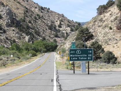
The beginning of the east side of Monitor Pass
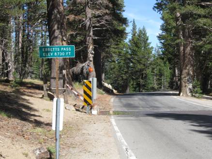
Ebbetts Pass East
Total elevation - 2,897 ft | Length 11.4 miles
Average grade - 4.8% (11%) | Rating - 1.59 (cat 1)
The east side of Ebbetts Pass is a very scenic climb. After a shallow start from the West Fork of the Carson River the grade gets a bit steeper as you ascend (last 7 miles average 6%). About halfway up the climb the road narrows and begins to switchback up the ridge and big mountain views appear. You pass a small lake near the top and the pass is signed (closed in winter - Stanislaus National Forest - 209 532-3671).
Directions - From Markleeville, CA head south on Route 89 to its junction with Route 4. From that junction continue west on 4 for several miles to the bridge over the West Fork of the Carson River where the listed climb begins.
Scenic Ebbetts Pass
Carson Pass East
Total elevation - 2,906 ft Length | 14.7 miles
Average grade
3.7% (8%) Rating | 1.24 (cat 1/2)
The east side of Carson Pass is a more moderate and scenic climb along Route 88 just south of Lake Tahoe. At the junction to Lake Tahoe continue straight on Route 88. The top 2 miles are particularly scenic as views of a mountain lake are to your left. The summit is signed and the route is a nice descent. Once you reach this point in the Death Ride essentially only a long descent back to the ride’s start awaits.
Directions - The climb begins just south of Lake Tahoe in tiny Woodfords, CA at the junction of Routes 88 and 89 by heading west on Route 88/89.
John can be reached at jsummers@wfubmc.edu